
| During the summers of 1999 and 2000, beaches at Huntington Beach, California, were repeatedly closed to swimming because of high bacteria levels in the surf zone. The city’s beaches are a major recreational and commercial resource, normally attracting millions of visitors each summer. One possible source of the bacterial contamination was the Orange County Sanitation District’s sewage outfall, which discharges treated wastewater 4.5 miles offshore at a depth of 200 feet. Scientists from the U.S. Geological Survey and cooperating organizations have been investigating whether ocean currents and waves transport the wastewater to the beaches. These studies indicate that bacteria from the outfall are not a significant source of the beach contamination. |
The wide sandy beaches at
Huntington Beach, California, just south of Los Angeles, attract residents and
visitors alike. Typically, more than 5 million people visit these beaches each
summer, helping to support a regional tourism industry of $80 million annually.
 |
|
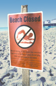 |
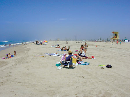
In most years, more than 5 million people visit the wide sandy beaches at Huntington Beach, California. Unfortunately, in recent summers, stretches of these beaches had to be repeatedly posted with advisories against swimming or even closed (left), because levels of live bacteria in the surf zone exceeded State public-health standards. These closures resulted in serious economic losses to local business communities. |
During the summers of 1999
and 2000, stretches of these beaches had to be repeatedly closed to swimming
or posted with advisories against swimming, because levels of live bacteria
in the surf zone exceeded beach sanitation standards in the California Health
and Safety Code (Assembly Bill 411, or AB411). Because people stayed away from
the beaches, local recreational and beachfront business communities suffered
serious economic losses.
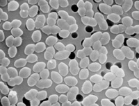 |
This photo shows many enterococci bacteria (magnified more than 5,000 times), one type of bacteria indicative of contamination from feces of humans or other warm-blooded animals. High levels of enterococci have been responsible for many of the beach closures at Huntington Beach. (Photo courtesy Centers for Disease Control and Prevention.) |
Local agencies conducted a variety of studies in 1999 and 2000 to try to determine the cause of the beach contamination at Huntington Beach. They investigated known sources of bacteria, such as broken sewer pipes, outflow from the Santa Ana River, feces of bird populations in coastal marshes, and the plume of treated wastewater from the Orange County Sanitation District’s (OCSD) ocean outfall, 4.5 miles (7 km) offshore at a depth of 200 feet (60 m). The beach closures were caused by elevated levels of three categories of bacteria—total coliform, fecal coliform, and enterococci. These bacteria, which live in the digestive tracts of warm-blooded animals including humans, are also found in the treated effluent discharged from the OCSD outfall. Because of this, it was suspected that coastal ocean processes might be bringing bacteria-rich effluent from the ocean outfall to shore.
To evaluate whether the
OCSD outfall could be the source for the bacterial contamination at Huntington
Beach, scientists from the U.S. Geological Survey (USGS) and cooperating organizations
designed and carried out an extensive study. Begun in the summer of 2001, this
study focused on the area’s coastal ocean circulation and transport pathways.
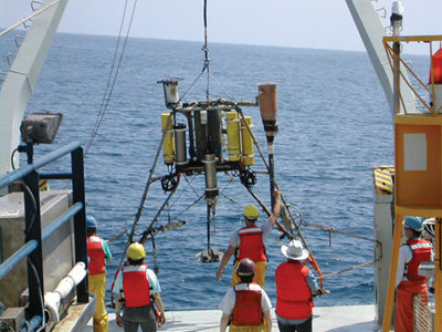 |
In the summer of 2001, scientists from the U.S. Geological Survey (USGS) and cooperating organizations designed and carried out an extensive study to evaluate whether the Orange County Sanitation District’s (OCSD) ocean outfall could be the source of bacterial contamination at Huntington Beach. This study focused on coastal ocean processes that could move significant volumes of bacteria-laden OCSD wastewater into the nearshore region and surf zone during summer months. The map below shows locations of instrument-mooring sites, hydrographic survey lines, and surf-zone bacteria sampling stations used in the USGS-led study. At mooring sites, arrays of instruments, such as the tripod shown below being lowered to the sea floor, monitored current velocity, temperature, salinity, and meteorological conditions. Hydrographic surveys used arrays of instruments towed or lowered from boats to measure the spatial distribution of temperature, salinity, ammonia content, bacteria concentrations, and other properties of the water column. |
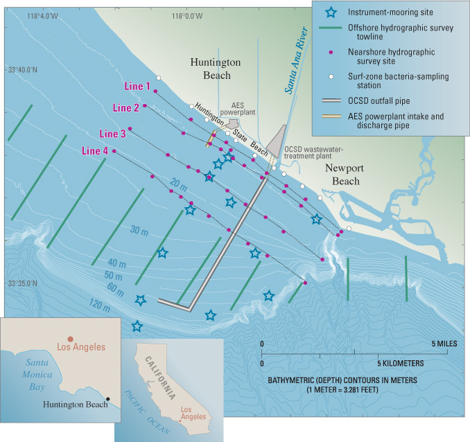 |
|
It was known from the 1999–2000
studies done by local agencies that the beaches were most often contaminated
during “spring” tides in the 2-week tidal cycle. Spring tides occur
when the gravitational pulls of the Moon and Sun reinforce each other, resulting
in the highest high waters and lowest low waters of this cycle. Additionally,
previous field observations and theoretical modeling indicated that, in summer,
the effluent plume from the OCSD outfall remains trapped below the thermocline,
a zone of rapid change in temperature that divides ocean water into cold dense
water below and warmer, less dense water above. In the ocean off southern California,
the thermocline is typically about 50 to 65 feet (15 to 20 m) below the sea
surface during the summer.
|
TEMPERATURE
PROFILES SHOW NEARSHORE COLD-WATER PULSES
|
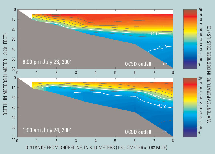 |
| These diagrams show water temperatures offshore of Huntington Beach on the evening of July 23–24, 2001. The upper diagram shows normal summer conditions, in which the thermocline (a zone of rapid change in temperature that divides ocean water into cold dense water below and warmer, less dense water above) is at a depth of about 15 to 20 meters (50 to 65 feet). The lower diagram shows conditions 7 hours later, when a pulse of cold water is moving nearshore below the thermocline. When the treated wastewater plume from the Orange County Sanitation District’s (OCSD) offshore outfall enters the ocean, it rises toward the thermocline and tends to stabilize and mix with a layer of water that has a temperature of 12 to 14°C (54 to 57°F). Water of that temperature was intermittently brought nearshore during July and August 2001, as shown by this example. However, U.S. Geological Survey and cooperating scientists found no association between the timing of these nearshore cold-water pulses and beach closures or postings on the shoreline caused by bacterial contamination. |
In light of these earlier
findings, the USGS-led study focused on coastal ocean processes, such as tides,
daily sea breezes, upwelling, and vertical mixing, that could move significant
volumes of bacteria-laden OCSD plume water from offshore below the thermocline
into the nearshore region and surf zone during summer months. In the summer
of 2001, scientists deployed a sophisticated set of oceanographic instruments
at 12 mooring sites in the coastal ocean off Huntington Beach and Newport Beach
to monitor current velocity, temperature, and salinity at selected depths in
the water column every few minutes for 4 months. Other instruments at these
sites collected real-time meteorological data at the sea surface. Additional
instruments were deployed in very shallow water to monitor the transport path-ways
between nearshore waters and the surf zone. Surf-zone water samples were collected
5 days a week in the early morning hours to measure bacterial levels from Huntington
Beach to Newport Beach.
A complementary hydrographic
mapping program used arrays of instruments towed or lowered from boats along
10 tow lines and at 40 sites between these lines and the shore during six surveys
centered around periods of maximum tidal range (spring tides). The surveys measured
the spatial distribution of temperature, salinity, ammonia content, bacteria
concentrations, and other properties of the water column. These properties were
chosen in part because they could be used to identify and track the relatively
low-salinity and ammonia-rich effluent from the OCSD plume. During these surveys,
additional surf-zone samples were collected every hour at 11 sites along local
beaches to provide additional data to evaluate the spatial and temporal distribution
patterns of bacteria from offshore to the surf zone.
|
SALINITY
PROFILES REVEAL BODIES OF RELATIVELY FRESHER WATER
|
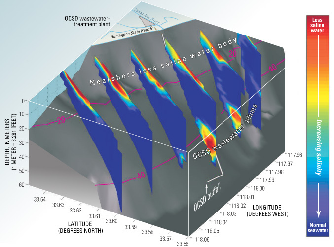 |
| This diagram shows salinity variations offshore of Huntington Beach in early July 2001, measured along hydrographic survey lines (see map). As shown in this diagram, salinity data from the summer of 2001 clearly show two distinct bodies of relatively less saline water—one in deeper water offshore associated with the Orange County Sanitation District’s (OCSD) wastewater outfall plume and one in shallower nearshore waters. The nearshore less saline water could be a possible source of the bacterial contamination that has caused beach closures at Huntington Beach. This water may be coming from the San Gabriel and Los Angeles Rivers, to the north, which carry urban runoff into the ocean. |
Analysis of the data collected
in 2001 show that the bacterial beach contamination at Huntington Beach is closely
associated with both tidal cycles and time of day. High values of all three
categories of fecal indicator bacteria were found preferentially at times of
spring tides. Additionally, values were high mainly at night, particularly for
enterococci. The data show that bacteria levels in the surf zone decreased to
very low levels during sunlit hours, even when beaches were closed or posted
for several days. However, previous studies have shown that the categories of
bacteria found in the OCSD outfall plume can survive for several days in the
deeper, colder water below the thermocline, where they are sheltered from ultraviolet
light.
When it enters the ocean, the treated wastewater from the OCSD outfall rises toward the thermocline, because it is fresher, warmer, and therefore less dense than the surrounding ocean water. The wastewater plume tends to stabilize and mix with a layer of water that has a temperature of 54 to 57°F (12 to 14°C) and for the most part is carried out of the area by alongshore currents. However, data show that water of that temperature was intermittently brought nearshore during July and August 2001. These cold-water pulses were the result of a combination of internal tides (tidal-cycle waves on density boundaries within the water column, like the thermocline) and daily circulation induced by sea breezes. It had been hypothesized that these mechanisms could bring wastewater from the OCSD plume into the proximity of the cooling-water intake and discharge pipes of the Huntington Beach AES Corporation electrical powerplant, where plume water could be sucked up and then be injected by the dis-charge jet into surface waters. The OCSD effluent could then easily move into the surf zone through buoyant spreading, wind forcing, or other processes. However, the USGS-led study found no as-sociation between the timing of nearshore cold-water pulses and beach closures or postings on the shoreline adjacent to the AES facility, which has been a hotspot for bacterial contamination.
Observations from the USGS-led
study provide no evidence that the bacteria found in the OCSD treated-effluent
plume reached any part of the shoreline at Huntington Beach in significant enough
quantities to cause beach closures or postings. The data show that when the
beaches have high bacteria levels, very nearshore water about 0.25 mile (0.4
km) from the beach also has measurable bacteria levels, although much below
AB411 standards. However, there was a spatial gap between this nearshore contamination
and the high levels of bacteria measured 2 miles (3.3 km) offshore below the
thermocline in the OCSD outfall plume. The lowest levels of bacteria were consistently
found offshore about 0.5 mile (0.8 km) from the beach. This spatial gap suggests
that the bacteria from the OCSD outfall are not the same bacteria that contaminate
the beaches. The bacteria causing the beach postings and closures at Huntington
Beach are most likely coming from other sources, such as water from local storm
drains, marshes, or some other as yet unidentified source.
|
BACTERIA
CONCENTRATIONS REVEAL GAP BETWEEN NEARSHORE AND OFFSHORE CONTAMINATION
|
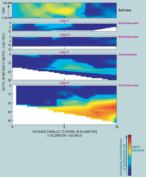 |
| In the summer of 2001, concentrations of Escherichia coli (E. coli) bacteria, an indicator of fecal contamination, were measured on the beach and through the water column along lines parallel to the shoreline at Huntington Beach (see map). This diagram is typical of the bacterial distribution pattern found. When the beaches have high bacteria levels, very nearshore water at Line 1, about 0.4 kilometer (0.25 mile) from the beach, also has measurable bacteria levels, although much below California health standards (AB411). However, there was a spatial gap between this nearshore contamination and the high levels of bacteria found at Line 4, 3.3 kilometers (2 miles) offshore in the Orange County Sanitation District’s (OCSD) wastewater outfall plume. The lowest levels of bacteria were consistently found offshore at Line 2, about 0.8 kilometer (0.5 mile) from the beach. This spatial gap suggests that the bacteria from the OCSD outfall are not the same bacteria that contaminate the beaches. |
Salinity data from the summer
of 2001 clearly show two distinct bodies of relatively fresher (less saline)
water—one offshore below the thermocline associated with the OCSD plume
and one in shallower nearshore waters. This observation corresponds well to
the spatial gap seen in the bacterial data. Although additional work needs to
be done to identify the source of the nearshore body of fresher water, it may
be coming from the San Gabriel and Los Angeles Rivers, to the north, which carry
urban runoff into the ocean.
Beach closures from bacterial
contamination continued at Huntington Beach in the summer of 2002. Even though
the data show that the OCSD outfall plume is almost certainly not the source
of that contamination, OCSD began chlorinating its wastewater discharge in the
fall of 2002. Samples taken from the OCSD offshore outfall plume since then
show low levels of bacteria, often below detection limits. However, periods
of bacterial beach contamination at levels above AB411 standards have occurred
at Huntington Beach after OCSD implemented chlorination, supporting the conclusion
of the USGS-led study that the OCSD outfall plume is not the culprit in the
beach contamination.
USGS and its cooperators are continuing to investigate how bacteria, other contaminants, and sediments are transported by coastal ocean processes not only off Huntington Beach but also in the larger region off southern California. Such research is only part of the USGS efforts to protect people’s lives and property from geologic and environmental hazards in the coastal zones of the United States.
By Jingping Xu, Marlene Noble, Leslie Rosenfeld, John Largier, Peter Hamilton, and Burt Jones
Edited by James W. Hendley
II and Peter H. Stauffer
Graphics by Susan Mayfield and Sara Boore; Web layout by Carolyn Donlin
COOPERATING
ORGANIZATIONS
MEC Analytical Systems, Inc.
Naval Postgraduate School
Orange County Sanitation District
Scientific Application International Corporation
Scripps Institute of Oceanography
University of Southern California
For more
information contact:
U.S. Geological Survey
345 Middlefield Road, Mail Stop 999
Menlo Park, CA 94025
(650) 329-5042
Coastal and Marine Geology Program
See also:
USGS Open-File Report 03-62, Huntington Beach Shoreline Contamination Investigation, Phase III
USGS Open-File Report 2004-1019, Huntington Beach Shoreline Contamination Investigation, Phase III, Final Report: Coastal Circulation and Transport Patterns: The Likelihood of OCSD's Plume Impacting Huntington Beach Shoreline
PDF version of this fact sheet (216 KB)
For questions about the content of this report, contact Jingping Xu
Download a copy of Acrobat Reader for free
| Help
| PDF help
| Geopubs main page | Fact
Sheets |
|
U.S. Geological Survey | Geologic
Division |
| Department
of the Interior | Privacy Statement
| Disclaimer | Accessibility
|
URL of this
page: https://pubs.usgs.gov/fs/2003/fs024-03/
Maintained by: Michael Diggles
Created: March 14, 2003
Last modified: May 13, 2005 (mfd)