
Proceedings of Conference VIII - Analysis of Actual Fault Zones in Bedrock
By Robert Speed1 and Robert Sharp2, Co-Organizers, and Jack F. Evernden2, Convener
U.S. Geological Survey Open-File Report 79-1239
Version 1.2
1979
Convened Under Auspices of
National Earthquake Hazards Reduction Program
1-5 April 1979
U.S. DEPARTMENT OF THE INTERIOR
CECIL D. ANDRUS, Secretary
U.S. GEOLOGICAL SURVEY
H. William Menard, Director
This report is preliminary and has not been reviewed for conformity with U.S. Geological Survey (USGS) editorial standards or with the North American Stratigraphic Code. Any use of trade, firm, or product names is for descriptive purposes only and does not imply endorsement by the U.S. Government.
1Northwestern University, Evanston, IL 60201
2345 Middlefield Road, Menlo Park, CA 94025
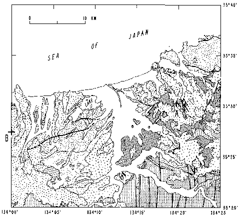
Detail of "Figure 5 - Geologic map of the Tottori, Japan, area showing surface faulting of 1943" from Bonilla, section I, chapter 2
Preface
A potential avenue of earthquake research that seems little explored except for the work of one or two individuals is the geologic analysis of actual fault zones to assess the geometry, motions, conditions, mechanisms, and dynamics of the faulting process. In particular, how do these aspects vary with depth and do faults preserve some record of seismic failure at focal depths? Is it possible to construct a generalized global model of depthwise properties of major fault zones in the upper lithosphere? The idea behind the Palm Springs conference was the question whether worldwide observations of active and ancient faults, now exposed in mines and at the surface by erosion, could reveal a set of common depthwise characteristics that could be synthesized into a general model.
The conference, therefore, brought together 25 scientists, chiefly observationalists, who have studied faults at varied exposure depths and employed different interpretive techniques. From these proceedings, the state of the art in understanding the properties of real fault zones may become clearer than was previously possible, and the feasibility of developing a fault model may be established. Because of time limitations, an attempt to develop a consensus fault model was not made at the conference.
The papers fall into two broad topical divisions:
1. Architecture and kinematics of fault zones: geometry of the region of failure; evolution of the larger structures of the zone; distributions of discrete slip and continuum deformation; fracture patterns; effects of lateral heterogeneities; contrasts in the character of the brittle and ductile regions and the nature of the transitional zone.
2. Conditions, mechanisms, and products of faulting: fault rocks and fine structure; origin and significance of cataclasite, mylonite, and pseudo-tachylite; fault plane and faulting-induced wallrock structures in brittle and ductile zones; interpretations from actual fault zones (in the light of experiments and theory) of mineral and failure mechanisms at various depth levels/rheologic zones; failure criteria in brittle and ductile zones and possible interactions between zones; thermal regime; existence and role of pore fluids; retention of fluids; stress differences at failure.
Contents
Architecture and Kinematics of Fault Zones
Ramsay, Shear zones
Bonilla, Historic Surface Faulting--Map Patterns, Relation to Subsurface Faulting, and Relation to Preexisting Faults
Sharp, Implications of surficial strike-slip fault patterns for simplification and widening with depth
Wallace and Morris, Characteristics of faults and shear zones as seen in mines at depths as much as 2.5 Km below the surface
McGarr, Pollard, Gay, and Ortlepp, Observations and analysis of structures in exhumed mine-induced faults
Speed, Extensional faulting in the Great Basin - kinematics and possible changes with depth
Lambert, Features and history of activity of major fault zones in the Berridale region, Snowy Mountains, southeastern Australia
Harland, A review of major faults in Svalbard
Flinn, The Walls Boundary fault, Shetland, British Isles
Simony, Observations on deep thrust faults on the west side of the southern Canadian Rockies
Hanks, Seismic widths of active crustal fault zones
Watterson, Strain and strain rate gradients at the ductile levels of fault displacements
Sharp, Some characteristics of the eastern Peninsular Ranges mylonite zone
Products, Conditions, and Mechanisms of Failure
Liechti and Zoback, Preliminary analysis of clay gouge from a well in the San Andreas fault zone in cetnral California
Sibson, Fault rocks and structure as indicators of shallow earthquake source processes
Logan, Friedman, Higgs, Dengo, and Shimamoto, Experimental studies of simulated gouge and their application to studies of natural fault zones
Wu, Roberson, Wang, and Mao, Fault zones, gauge, and mechanical properties of clays under high pressure
Engelder, Evidence for variation of friction along natural fault zones
Kohlstedt, Cooper, Weathers, and Bird, Paleostress analysis of deformation-induced microstructures - Moine thrust zone and Ikertoq shear zone
Weathers, Bird, Cooper, and Kohlstedt, Microstructure and stress analysis of the Mullen Creek - Nash Fork shear zone, Wyoming
Etheridge and Wilkie, The geometry and microstructure of a range of QP-mylonite zones - a field test of the recyrstallized grainsize palaeopiezometer
Bridgwater, Chemical and isotopic redistribution in zones of ductile deformation in a deeply eroded mobile belt
Sibson, Fluid flow around faults - field evidence for dilatancy pumping?
Masch, Deformation and fusion of two fault rocks in relation to their depth of formation - the Hyalomylonite of Langtang (Himalaya) and the pseudotachylites of the Silvretta nappe (eastern Alps)
Scholz, Beavan, and Hanks, Metamorphism, argon depletion, heat flow, and stress on the alpine fault
Zoback, Magnitude of shear stress on the San Andreas Fault: implications from a stress measurement profile at shallow depth [not included in the original paper publication due to poor print quality but is basically the same as his Science article and has been included here]
Comments
A. Summaries of Each Conference Day
Summary of discussion on papers concerned with fault geometry, especially involved observations in the upper or brittle
Summary of Discussion on Kohlstedt's, Weathers', and Etheridg's Papers
Comments of Talks by Watterson, Sibson, and Logan
Summary of Discussion, Papers by Bridgewater, Sibson, Masch, and Scholz, et al.
B. Comment by Attendee
Comments by John Logan
Credits
Manual ("Doc") Bonilla began this project by producing a Web version of his paper, pages 36-65. Carolyn Donlin encouraged expanding the project which she put online. In order to make the entire publication available, Mary Jane Coombs scanned a paper copy of remainder of the publication and did OCR on the text. Michael Diggles compiled the resulting Portable Document Format (PDF) file, added bookmarks and thumbnails, and built the html front-end.
Report in PDF Format
The report is provided here as a PDF. The file has thumbnails and will open with bookmarks to each of the sections and chapters.
To view PDF publications on this Web server, you will need Adobe Acrobat Reader.

Click the link above to view the report in PDF format (208 KB with links to 120 MB of chapters).
Version history
CLICK HERE to view the version history.
Individual files
CLICK HERE to access the individual chapters. To download a file to your computer, right click (PC) or click-and-hold (Mac) on the file name and follow the pop-up menu.
The URL of this page is http://pubs.usgs.gov/of/1979/of79-1239/
Date created: October 22, 2000
Last modified: May 27, 2005
Email questions about this Web page to
Michael Diggles (mdiggles@usgs.gov)