
By M.G. Bonilla1
U.S. Geological Survey Open-File Report 82-732
Version 1.0
1982
Prepared with partial support from
U.S. Nuclear Regulatory Commission
U.S. DEPARTMENT OF THE INTERIOR
JAMES G. WATT, Secretary
U.S. GEOLOGICAL SURVEY
Dallas L. Peck, Director
This report is preliminary and has not been reviewed for conformity with U.S. Geological Survey (USGS) editorial standards or with the North American Stratigraphic Code. Any use of trade, firm, or product names is for descriptive purposes only and does not imply endorsement by the U.S. Government.
1345 Middlefield Road, Menlo Park, CA 94025
The deformation discussed here is the permanent deformation of the ground arising from the sudden displacement of buried rock masses that generates an earthquake. Such deformation includes both faulting that ruptures the surface of the earth and permanent distributed deformation of the rocks surrounding the earthquake-generating fault.
Surface faulting also results from slow movement of large sedimentary deposits (for example, the "growth faults" of the Gulf Coast), from withdrawal of subsurface fluids, or from movement of salt, gypsum, or anhydrite deposits. Such faulting can damage structures, but, because it is aseismic or produces only very small earthquakes, it is not treated in this report, nor is faulting associated with volcanic activity.
Permanent deformation of the ground also results from failure phenomena within surficial sediments in response to earthquake shaking. Examples include landslides, earth flows, lateral spreads and settlements. Such distortions are regarded as secondary effects because they are induced by earthquake shaking, and are not discussed here.
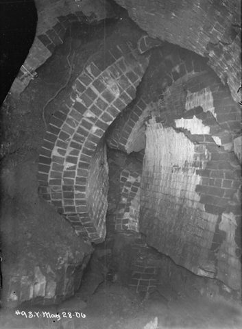
Damage to brick-lined tunnel by about 2 m of right slip on the San Andreas fault, 1906. The tunnel was repaired and restored to use. Photo courtesy of San Francisco Water Department
