U.S. Geological Survey Open-File Report Open-File Report 95–681
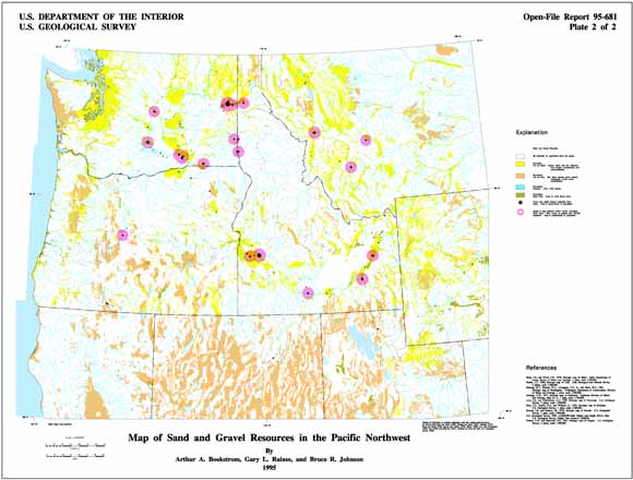
The sources of geologic information for the phosphate and natural aggregate maps were the geologic maps of California (Jennings, 1977), Idaho (Bond and Wood, 1978), Montana (Ross, Andres and Witkind, 1955), Nevada (Stewart and Carlson, 1978), Oregon (Walker and MacLeod, 1991), Utah (Hintze, 1980), Washington (Hunting and others, 1961), and Wyoming (Love and Christiansen, 1985). The individual state geologic maps were combined to produce a composite geologic map of the Pacific Northwest with over 800 rock units, as described in Johnson and Raines (1995). The state geologic maps were processed digitally, as follows: the source material was scanned, the scanned image was vectorized and topologically structured, the lines and polygons were edited and proofed, attributes were added and proofed, the map was transformed from scanner units to geographic coordinates, and finally, map distortions were removed by rubber-sheeting. With the state geology available as a composite digital map, new interpretations and reclassifications of the bedrock geology were easily derived. Geology shown on maps presented in this report was derived from the composite geologic map. Locations of phosphate mines and prospects were extracted from digital data files of the U.S. Geological Survey Mineral Resource Documentation System (MRDS). Swanson, McKelvey, and Sheldon (1953) also provided information on western phosphate deposits. Locations of rivers and perennial streams used on the Sand and Gravel Map were obtained from USGS 1:2,000,000 scale Digital Line Graphs (U.S. Geological Survey, 1990). Locations of cities and towns used on the Sand and Gravel Map were obtained from a GIS coverage supplied by the ICBEMP. The following text describes the phosphate and sand and gravel maps of the Pacific Northwest.
For additional information:
Contact Information, Geology, Minerals, Energy, and Geophysics Science Center
Mineral and Environmental Resources, Spokane Office
U.S. Geological Survey
904 W. Riverside Ave., Room 202
Spokane, WA 99201
http://minerals.usgs.gov/west/
Bookstrom, A.A., Raines, G.L., and Johnson, B.R., 1995, Digital mineral resource maps of phosphate and natural aggregate for the Pacific Northwest; a contribution to the Interior Columbia River Basin Ecosystem Management Project: U.S. Geological Survey Open-File Report 95–681, available at https://pubs.usgs.gov/of/1995/of95-681/.
This report is presented in Portable Document Format (PDF); the latest version of Adobe Reader or similar software is required to view it. Download the latest version of Adobe Reader, free of charge.
Last modified April 18, 2012
First posted 1995

![]() U.S. Department of the Interior |
U.S. Geological Survey
U.S. Department of the Interior |
U.S. Geological Survey
URL: http://pubsdata.usgs.gov/pubs/of/1995/of95-681/index.html
Page Contact Information: GS Pubs Web Contact
Page Last Modified: Wednesday, 07-Dec-2016 15:59:09 EST
