
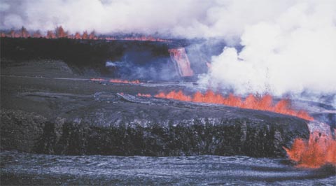
Telephoto view to the south across Kilauea Caldera from the USGS Hawaiian Volcano Observatory, July 19, 1974, 13:25 hrs. Lava fountains up to 25 m high on the skyline south of Keanakako’i Crater feed lava cascades into the Kilauea Crater. Low fountains at the Crater's north rim feed flows that have just cut the Crater Rim Road. High fountains on the floor of Kilauea Caldera (foreground) mark the easternmost extent of the caldera-floor fountains that extend more than a kilometer to the west of this photo. USGS photo by John C. Forbes.
Nearly all known eruptions of Kilauea, one of the most active volcanoes on Earth, have taken place either within its summit region or along its two rift zones–the east-rift zone (ERZ) and the southwest-rift zone (SWRZ)–that radiate from the summit (fig. 1; Holcomb, 1987). In 1974, Kilauea exhibited an especially wide range of eruptive behavior. During that year, the long-lived Mauna Ulu eruption in the upper ERZ (Swanson and others, 1979; Tilling and others, 1987) declined and ceased, two short-lived eruptions–one in July, another in September–occurred within Kilauea's summit caldera and the upper ERZ. In December a brief, vigorous outbreak took place in an area between the upper SWRZ and the Koae Fault System (KFS) (fig. 1). Each of these eruptions broke out in different areas, and the lavas of each had distinctive chemical compositions. Seismic and ground-deformation activity associated with the eruptions suggested that each was related to a general pattern of westerly migration of a shallow magma source. Although selected aspects of the 1974 eruptions have been treated briefly (Peterson, 1976; Tilling and others, 1976; Pollard and others, 1983; Lipman and others, 1985; Klein and others, 1987; Dvorak and Okamura, 1987; Hazlett, 1993), they have never been documented in any detail.
The purpose of this paper is twofold: (1) to present a complete account of these contrasting yet related eruptions, thus filling a gap in the published narratives of recent activity of Kilauea; and (2) to examine their significance within a broader context of regional magmatic and eruptive dynamics. In hindsight, one unanticipated benefit of the long delay in preparing this paper is that we have gained a longer term historical perspective and can view these three eruptions within a multidecade context of the eruptive behavior of not only Kilauea, but also of the adjacent Mauna Loa.
Download this report as a 43-page PDF file (pp1613.pdf; 6.9 MB)
For questions about the scientific content of this report, contact Bob Tilling
Download a free copy of Adobe Reader
This report is also available in printed form by writing:
USGS Information Services
Box 25286, Federal Center
Denver, CO 80225
Telephone: 888-ASK-USGS
E-mail: infoservices@usgs.gov
| Help
| PDF help |
| Geopubs main page
| Professional
Papers on Geopubs |
| U.S. Department of the Interior
| U.S. Geological Survey
| Geologic Division |
| Privacy statement
| Disclaimer
| Accessibility
The URL of this page is:
http://pubs.wr.usgs.gov/pp/pp1613/
Please send comments and suggestions, or report problems, to:
Michael Diggles
Created on: March 27, 2000 (cad)
Updated: January 19, 2007 (bwr, mfd)